Analyzing land use in the UK

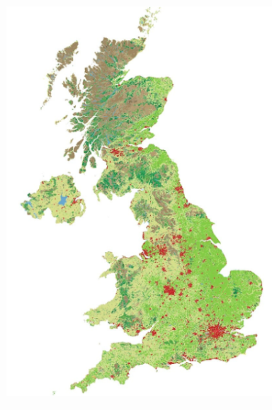
A posting at the website of Local Authority Building Control in the United Kingdom (UK) summarizes what has been learned about land use in that country via analysis of high definition satellite images.[1]  Based on these digital images, maps were created consistent with CORINE (coordination of information on the environment) Land Cover protocol of the European Environment Agency.

Key land classifications include:

  • continuous urban fabric--the most built-up urban areas, where at least 80% of the land surface is built on and up to 20% is gardens or small parks
  • discontiguous urban fabric--where 50% to 80% of the land surface is built on
  • Industrial and commercial areas
  • green urban areas -- golf course, football fields, parks, etc
  • farmland--pasture, arable land, vineyards and orchards
  • natural land--forests, lakes, and moors (low growing vegetation on acidic soils)

Interestingly, continuous urban fabric (CUF) only accounts for 0.1% of UK land and discontiguous urban fabric accounts for 5.6% of the land area.

Screenshot 2018-01-31 15.25.30.png

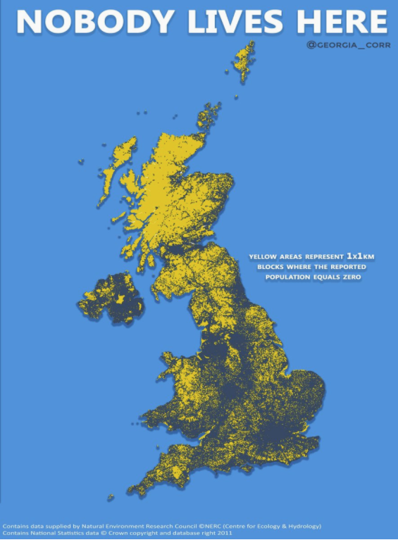
A map posted on Twitter by @georgia_coor highlights those areas of the UK where nobody lives.

Screenshot 2018-02-01 12.11.01.png

[1] Local Authority Building Control is a network of approximately 3,000 professional surveyors. It represents all local government building control teams in England and Wales. Their goal is to ensure buildings are safe, healthy and efficient to meet the standards set by the building regulations.
 

H. Pike Oliver

H. Pike Oliver focuses on master-planned communities. He is co-author of Transforming the Irvine Ranch: Joan Irvine, William Pereira, Ray Watson, and THE BIG PLAN, published by Routledge in 2022.

Early in his career, Pike worked for public agencies, including the California Governor's Office of Planning and Research, where he was a principal contributor to An Urban Strategy for California. For the next three decades, he was involved in master-planned development on the Irvine Ranch in Southern California, as well as other properties in western North America and abroad.

Beginning in 2009, Pike taught real estate development at Cornell University and directed the undergraduate program in Urban and Regional Studies. He relocated to Seattle in 2013 and, from 2016 to 2020, served as a lecturer in the Runstad Department of Real Estate at the University of Washington, where he also served as its chair.

Pike graduated from San Francisco State University's urban studies and planning program and received a master's degree in urban planning from UCLA. He is a member of the American Planning Association and the Urban Land Institute and a founder and emeritus member of the California Planning Roundtable.

https://urbanexus.com
Previous
Previous

Private residential construction spending in the USA

Next
Next

Family of armed Malhuer occupier files wrongful death lawsuit