
Andrew Miller on California Forever’s mobility vision—and what he omits
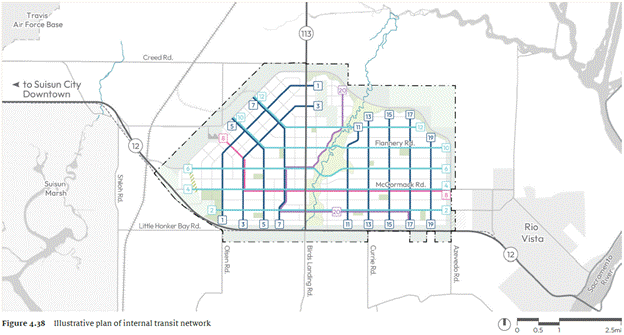
The Suisun Expansion’s planned transit network. Coloured lines indicate transit routes. Figure 4.38 (p. 115) of the proposed Suisun Expansion Specific Plan
Andrew Miller’s California Forever’s mobility vision: Locking in the right things, post on his Substack called, Changing Lanes, on April 28, 2026, argues that the decisive factor in whether the proposed East Solano city succeeds is locking in the correct mobility geometry before development begins. His central and valid claim is that early decisions about street structure, density, and transit right‑of‑way will determine the city’s long‑term transportation outcomes because mobility patterns, once established, are extraordinarily difficult to reverse.
What Miller says California Forever is getting right
Miller highlights three foundational commitments that he believes the project team has correctly prioritized:
A fine-grained, walkable street grid.
He argues that a tight block structure is the prerequisite for walkability, transit legibility, and incremental densification. Without it, no amount of later policy intervention can create a walkable city.
Early protection of dedicated transit right‑of‑way.
Miller emphasizes that reserving transit corridors before development is the single most important structural decision. It prevents future political fights over reallocating car lanes and enables staged deployment (bus → BRT → LRT) without redesigning the city.
Density commitments aligned with transit viability.
He warns that if density targets are watered down during entitlement negotiations, the entire mobility vision collapses. Transit cannot succeed without sufficient residential and employment concentration.
What he believes is at risk
Miller cautions that political compromise could erode the fundamentals of mobility. His concerns include:
Pressure for wider arterials, superblocks, and excessive parking minimums, all of which would undermine walkability.
Under‑specification of transit commitments, such as failing to define protected corridors, minimum service levels, or funding mechanisms.
Allowing auto‑oriented retail formats that break the urban fabric and create long-term liabilities.
What Miller does not address: the regional highway burden
Miller does not attempt to estimate the regional highway improvements required to accommodate vehicular trips likely to be generated by a city of 400,000 residents.
Even under an extremely optimistic scenario—say, a 50% reduction in auto ownership relative to a comparable suburban area in California—the absolute number of vehicles would still be significant. A city of 400,000 with half the typical auto ownership rate would still generate:
200,000+ registered vehicles,
hundreds of thousands of daily trips, and
tens of thousands of peak‑hour regional trips.
This would have unavoidable implications for:
SR‑12 (already a high‑collision corridor with limited passing opportunities)
SR‑113 (a two‑lane rural highway not designed for metropolitan commuting volumes)
I‑80, one of the most congested interstates in Northern California
I‑5, which would absorb long‑distance and interregional travel demand
Miller’s analysis focuses on internal mobility geometry—street grids, transit corridors, density—but does not engage with the external mobility consequences: the regional highway system that would bear the majority of long‑distance trips regardless of how walkable the new city is internally.
This omission matters because regional highway capacity is not easily expanded in Solano County due to right‑of‑way constraints, environmental sensitivities (vernal pools, Jepson Prairie, Suisun Marsh), and funding challenges.
In short:
Even a highly walkable, transit‑ready city of 400,000 would generate a massive increase in regional automobile traffic—an issue Miller does not address.